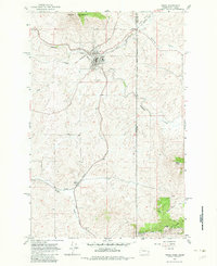
1964 Map of Tekoa
USGS Topo · Published 1983About this map
The railroad junction of Tekoa serves as the hub of this mid-century landscape, where the Chicago Milwaukee St Paul and Pacific and Union Pacific lines intersect. The terrain is defined by the transition from the rolling Palouse hills to the heights of Tekoa Mountain and the prominent Liberty Butte. Outside of the main town, small settlements like Seltice and Willard are connected by a network of winding creeks, including Hangman Creek and Moctileme Creek.
Find a feature on this map
28 named features on this map. Tap any name to fly to it.
Don’t see what you’re looking for? This feature index may not catch every label — zoom into the map to look around manually.
Map Details
Editions of this 1964 Tekoa Map
Other maps of this area

1903 · Oakesdale
USGS Topo · 1:125,000

1905 · Oakesdale
USGS Topo · 1:125,000

1954 · Fairfield
USGS Topo · 1:62,500

1955 · Spokane
USGS Topo · 1:250,000

1957 · Plummer
USGS Topo · 1:62,500

1957 · Tensed
USGS Topo · 1:62,500

1958 · Spokane
USGS Topo · 1:250,000

1964 · Oakesdale
USGS Topo · 1:24,000

1964 · Tekoa
USGS Topo · 1:24,000
1964 · Garfield
USGS Topo · 1:24,000