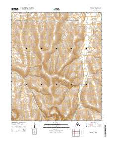
2014 Map of Teller C-5 NE
USGS Topo · Published 2014About this map
Bering Land Bridge National Preserve anchors the northern extent of this landscape, where the Seward Peninsula's drainage patterns reveal a complex network of arctic waterways. The Yankee River flows through the western portion of the quadrangle, joined by tributaries including Alma Cr and Mariposa Cr. In the eastern reaches, the terrain is defined by the winding course of York Cr. This 2014 representation of the Nome region illustrates the remote hydrology of the Alaskan wilderness, showing how these drainages carve through the surveyed townships of t4n r41w and t3n r40w. The map provides a precise record of the natural boundaries and water systems as they existed in the early 21st century.
Find a feature on this map
9 named features on this map. Tap any name to fly to it.
Don’t see what you’re looking for? This feature index may not catch every label — zoom into the map to look around manually.
Map Details
Editions of this 2014 Teller C-5 NE Map
This is the sole edition of this map. No revisions or reprints were ever made.
Other maps of this area

1950 · Teller
USGS Topo · 1:250,000

1950 · Teller D-5
USGS Topo · 1:63,360

1950 · Teller C-4
USGS Topo · 1:63,360
1950 · Teller D-4
USGS Topo · 1:63,360

1950 · Teller C-5
USGS Topo · 1:63,360

1951 · Teller
USGS Topo · 1:250,000

1957 · Teller
USGS Topo · 1:250,000

1958 · Teller
USGS Topo · 1:250,000
2014 · Teller C-4 SW
USGS Topo · 1:25,000
2014 · Teller C-5 SW
USGS Topo · 1:25,000