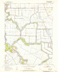
1952 Map of Terminous
USGS Topo · Published 1953About this map
Terminous sits at the heart of a complex network of waterways and reclaimed agricultural tracts in the California Delta during the early 1950s. The landscape is defined by human engineering, where numerous siphons, pump houses, and levees manage the flow between the Mokelumne River and the San Joaquin River. Large agricultural parcels like the Shin Kee Tract, Empire Tract, and Rindge Tract dominate the terrain, separated by narrow channels such as White Slough and Potato Slough.
Find a feature on this map
51 named features on this map. Tap any name to fly to it.
Don’t see what you’re looking for? This feature index may not catch every label — zoom into the map to look around manually.
Map Details
Editions of this 1952 Terminous Map
3 editions found
Other maps of this area

1894 · Lodi
USGS Topo · 1:125,000

1910 · New Hope
USGS Topo · 1:31,680

1910 · Castle
USGS Topo · 1:31,680

1910 · Bouldin
USGS Topo · 1:31,680

1910 · Woodbridge
USGS Topo · 1:31,680

1910 · Headreach
USGS Topo · 1:31,680

1910 · Isleton
USGS Topo · 1:31,680

1913 · Woodward Island
USGS Topo · 1:31,680

1913 · Stockton
USGS Topo · 1:31,680

1913 · Holt
USGS Topo · 1:31,680