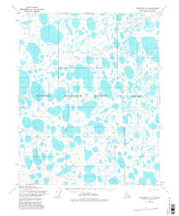
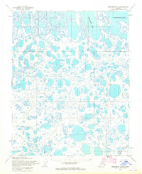
1955 Map of Teshekpuk A-2
USGS Topo · Published 1982About this map
The National Petroleum Reserve in Alaska dominates this landscape, characterized by a dense network of lakes and ponds typical of the Arctic coastal plain. This 1955 survey, which was annotated just after the mid-century, captures the region's early transition into a strategic resource area. Movement through this water-heavy terrain was facilitated by a sparse network of Tractor Trails, which likely served as the primary conduits for exploration and transport in an environment where permanent infrastructure was nearly non-existent. Scattered throughout the quadrangle are small named points of interest such as Bess, Seer, Gisk, and Flo, which may relate to early survey markers or temporary outposts in this isolated northern territory. The map is a meticulous record of the hydrology and elevation patterns that dictated travel and survey work before modern technological shifts in Arctic exploration.
Find a feature on this map
8 named features on this map. Tap any name to fly to it.
Don’t see what you’re looking for? This feature index may not catch every label — zoom into the map to look around manually.
Map Details
Editions of this 1955 Teshekpuk A-2 Map
2 editions found
Other maps of this area

1951 · Teshekpuk
USGS Topo · 1:250,000

1951 · Ikpikpuk River
USGS Topo · 1:250,000

1955 · Teshekpuk
USGS Topo · 1:250,000
1955 · Teshekpuk A-2
USGS Topo · 1:63,360
1955 · Teshekpuk A-3
USGS Topo · 1:63,360
1955 · Teshekpuk B-3
USGS Topo · 1:63,360

1955 · Teshekpuk A-1
USGS Topo · 1:63,360
1955 · Teshekpuk B-2
USGS Topo · 1:63,360

1955 · Teshekpuk B-1
USGS Topo · 1:63,360

1956 · Ikpikpuk River
USGS Topo · 1:250,000