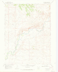
1969 Map of The Nipple NE
USGS Topo · Published 1973About this map
The Little Snake River meanders through this high-desert portion of Moffat County, carving a distinct valley that defines the local topography. This late 1960s survey documents a landscape focused on resource extraction and river crossings, most notably at the Edinger Bridge. The infrastructure of the era is clearly visible through the presence of a large Pipeline cutting across the northern reaches and several Gas Wells and Drill Holes scattered throughout the drainage basins.
Find a feature on this map
12 named features on this map. Tap any name to fly to it.
Don’t see what you’re looking for? This feature index may not catch every label — zoom into the map to look around manually.
Map Details
Editions of this 1969 The Nipple NE Map
3 editions found
Other maps of this area

1916 · Craig
USGS Topo · 1:125,000

1954 · Vernal
USGS Topo · 1:250,000

1954 · Rawlins
USGS Topo · 1:250,000

1954 · Rock Springs
USGS Topo · 1:250,000

1954 · Craig
USGS Topo · 1:250,000

1957 · Craig
USGS Topo · 1:250,000

1958 · Rawlins
USGS Topo · 1:250,000

1958 · Vernal
USGS Topo · 1:250,000

1958 · Rock Springs
USGS Topo · 1:250,000

1958 · Craig
USGS Topo · 1:250,000