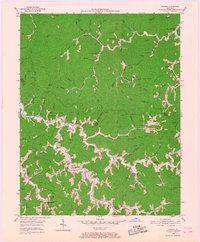
1954 Map of Thomas
USGS Topo · Published 1968About this map
Johns Creek and Brushy Creek dominate this central Kentucky landscape, carving deep valleys that define the settlement patterns of the 1950s. The map illustrates a highly dispersed rural community structure where life was organized around the narrow creek bottoms and the schools that served them. Tiny hamlets and post offices like Thomas P O, McCombs, and Gulhare are connected by winding roads that follow the water's edge, while the ridgelines like Chestnut Knob remain largely uninhabited.
Find a feature on this map
79 named features on this map. Tap any name to fly to it.
Don’t see what you’re looking for? This feature index may not catch every label — zoom into the map to look around manually.
Map Details
Editions of this 1954 Thomas Map
3 editions found
Other maps of this area

1886 · Prestonsburg
USGS Topo · 1:125,000

1887 · Warfield
USGS Topo · 1:125,000

1891 · Warfield
USGS Topo · 1:125,000

1892 · Prestonsburg
USGS Topo · 1:125,000

1910 · Naugatuck
USGS Topo · 1:48,000

1912 · Naugatuck
USGS Topo · 1:62,500

1914 · Laynesville
USGS Topo · 1:48,000

1914 · Inez
USGS Topo · 1:48,000

1915 · Williamson
USGS Topo · 1:48,000

1915 · Naugatuck
USGS Topo · 1:48,000