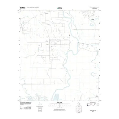
2010 Map of Thompsons
USGS Topo · Published 2010About this map
The Brazos River meanders through this portion of Fort Bend County, defining a landscape of low-lying wetlands and industrial sites in the early 21st century. The settlement of Thompsons sits near the northern boundary, while the legacy of the region's petroleum industry is represented by the Thompsons Oil Field and the nearby Humble Camp. The terrain is marked by an intricate network of waterways, including the winding Oyster Creek, Rabbs Bayou, and Cow Bayou, alongside several significant bodies of water such as Sawmill Lake and Cow Lake. In the southern reaches, large-scale water management is evident at Reservoir Number 8 and Turner Lake. Significant local landmarks like the Booker T Washington School and the developing residential area of Sienna Plantation illustrate the evolving social and educational footprint of the community. This topographic study also identifies natural features like Steep Gully and the low Ridge that break the otherwise level coastal plain.
Find a feature on this map
36 named features on this map. Tap any name to fly to it.
Don’t see what you’re looking for? This feature index may not catch every label — zoom into the map to look around manually.
Map Details
Editions of this 2010 Thompsons Map
This is the sole edition of this map. No revisions or reprints were ever made.
Other maps of this area

1920 · Almeda
USGS Topo · 1:31,680

1943 · Rosharon
USGS Topo · 1:31,680

1943 · Juliff
USGS Topo · 1:31,680

1950 · Houston
USGS Topo · 1:250,000

1953 · Lake George
USGS Topo · 1:24,000

1953 · Damon
USGS Topo · 1:24,000

1953 · Otey
USGS Topo · 1:24,000

1953 · Thompsons
USGS Topo · 1:24,000
1955 · Almeda
USGS Topo · 1:24,000

1955 · Sugar Land
USGS Topo · 1:62,500