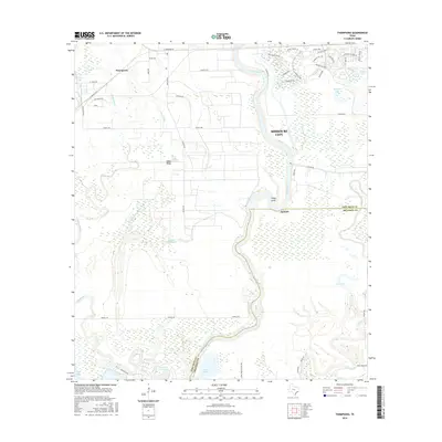
2016 Map of Thompsons
USGS Topo · Published 2016About this map
The Brazos River carves a winding path through this portion of Southeast Texas, defining the landscape between Missouri City and Alvin. The map reveals a transition from traditional rural settlements like Thompsons and Rabbs Ridge to contemporary suburban developments, particularly evident in the densely plotted streets of the Sienna Plantation area near Cow Bayou and Sawmill Lake. Significant water management features dominate the southern terrain, including Reservoir Number 8 and Pilant Lake, alongside the extensive drainage network of Rabbs Bayou and Oyster Creek. The influence of the regional petroleum industry is noted through local infrastructure such as Oilfield Rd and Texaco Rd. This survey provides a look at the modern convergence of residential expansion and the historic agricultural and industrial roots of the Brazos bottomlands near the Fort Bend and Brazoria county line.
Find a feature on this map
60 named features on this map. Tap any name to fly to it.
Don’t see what you’re looking for? This feature index may not catch every label — zoom into the map to look around manually.
Map Details
Editions of this 2016 Thompsons Map
This is the sole edition of this map. No revisions or reprints were ever made.
Other maps of this area
1920 · Almeda
USGS Topo · 1:31,680
1943 · Rosharon
USGS Topo · 1:31,680
1943 · Juliff
USGS Topo · 1:31,680
1950 · Houston
USGS Topo · 1:250,000
1953 · Lake George
USGS Topo · 1:24,000
1953 · Damon
USGS Topo · 1:24,000
1953 · Otey
USGS Topo · 1:24,000
1953 · Thompsons
USGS Topo · 1:24,000
1955 · Almeda
USGS Topo · 1:24,000
1955 · Sugar Land
USGS Topo · 1:62,500