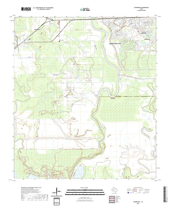
2022 Map of Thompsons
USGS Topo · Published 2022About this map
Brazos River meanders through this landscape on the border of Fort Bend and Brazoria counties, shaping a terrain of bayous and ridges. To the west, the community of Thompsons sits near the BNSF Railway, while the eastern portion of the map shows the suburban expansion of Missouri City and Sienna Plantation. This area is rich with family and community history, evidenced by several burial sites including the Mount Pilgrim Baptist Church Cem, Jones Cem, and Edwards Cem. The intricate network of water features like Rabbs Bayou, Cottonwood Bayou, and Oyster Creek highlights the low-lying coastal prairie environment. Land use is a mix of agricultural history and modern development, with landmarks such as Rabbs Ridge and Turner Lake remaining prominent alongside a dense network of newer trails like the Big Creek Loop Trl and River View Trl.
Find a feature on this map
85 named features on this map. Tap any name to fly to it.
Don’t see what you’re looking for? This feature index may not catch every label — zoom into the map to look around manually.
Map Details
Editions of this 2022 Thompsons Map
This is the sole edition of this map. No revisions or reprints were ever made.
Other maps of this area

1920 · Almeda
USGS Topo · 1:31,680

1943 · Rosharon
USGS Topo · 1:31,680

1943 · Juliff
USGS Topo · 1:31,680

1950 · Houston
USGS Topo · 1:250,000

1953 · Lake George
USGS Topo · 1:24,000

1953 · Damon
USGS Topo · 1:24,000

1953 · Otey
USGS Topo · 1:24,000

1953 · Thompsons
USGS Topo · 1:24,000
1955 · Almeda
USGS Topo · 1:24,000

1955 · Sugar Land
USGS Topo · 1:62,500