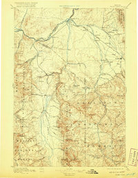
1895 Map of Three Forks
USGS Topo · Published 1920About this map
Virginia City and the surrounding mining districts in the Madison Range anchor the southwestern corner of this reconnaissance survey. The map details a period of significant growth along the Northern Pacific Railroad, which follows the river valleys through Manhattan, Logan, and Three Forks. The confluence of the Jefferson River and the Gallatin River forms the headwaters of the Missouri River, creating a natural hub for early Montana settlements. High-altitude landmarks like Lone Mountain and Gallatin Peak tower over the Madison Valley, while local commerce is represented by sites such as Matthews Hot Springs and Gums Ranch. The land is further defined by the early boundaries of the Gallatin National Forest and Madison National Forest, reflecting the era's transition from pioneer mining camps like Nevada and Adobe toward established agricultural and rail centers.
Find a feature on this map
108 named features on this map. Tap any name to fly to it.
Don’t see what you’re looking for? This feature index may not catch every label — zoom into the map to look around manually.
Map Details
Editions of this 1895 Three Forks Map
5 editions found

Other maps of this area

1885 · Gallatin
USGS Topo · 1:125,000

1885 · Gallatin
USGS Topo · 1:125,000

1886 · Fort Logan
USGS Topo · 1:250,000

1886 · Little Belt Mts.
USGS Topo · 1:250,000

1888 · Three Forks
USGS Topo · 1:250,000

1889 · Helena
USGS Topo · 1:250,000

1891 · Livingston
USGS Topo · 1:250,000

1893 · Helena
USGS Topo · 1:250,000

1893 · Dillon
USGS Topo · 1:250,000

1893 · Livingston
USGS Topo · 1:250,000