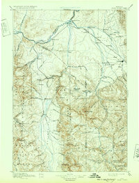
1895 Map of Three Forks
USGS Topo · Published 1932About this map
The Missouri River finds its origins at the confluence of three great waterways in this late 19th-century survey of southwestern Montana. The settlement of Three Forks sits at the nexus where the Jefferson River, Madison River, and Gallatin River merge, forming a critical geographic point for early pioneers and surveyors. To the west, the territorial capital era is represented by Virginia City and the nearby mining camps of Nevada, Adobe, and Junction. These settlements, along with the ranching outposts of Gums Ranch and Spring Hill, illustrate a landscape transitioning from the gold rush to established agriculture and rail commerce.
Find a feature on this map
114 named features on this map. Tap any name to fly to it.
Don’t see what you’re looking for? This feature index may not catch every label — zoom into the map to look around manually.
Map Details
Editions of this 1895 Three Forks Map
5 editions found

Other maps of this area

1885 · Gallatin
USGS Topo · 1:125,000

1885 · Gallatin
USGS Topo · 1:125,000

1886 · Fort Logan
USGS Topo · 1:250,000

1886 · Little Belt Mts.
USGS Topo · 1:250,000

1888 · Three Forks
USGS Topo · 1:250,000

1889 · Helena
USGS Topo · 1:250,000

1891 · Livingston
USGS Topo · 1:250,000

1893 · Helena
USGS Topo · 1:250,000

1893 · Dillon
USGS Topo · 1:250,000

1893 · Livingston
USGS Topo · 1:250,000