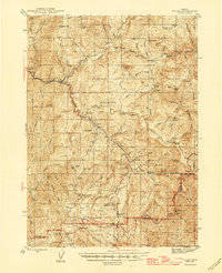
1944 Map of Tiller
USGS Topo · Published 1946About this map
Tiller sits at the junction of the South Umpqua River and Dampier Creek, serving as a central point in this timber and ranching landscape during the mid-1940s. The map reveals an economy built on natural resource extraction and isolated homesteads, with several active or historic operations such as the Banfield Mine, Red Cloud Mine, and the Old Johnson Mill. Education in these drainage basins was localized at small institutions like Drew Sch and Tison Sch, while the Tiller Ranger Station and Summit Guard Sta emphasize the importance of federal forest management across the Umpqua National Forest and Rogue River National Forest. Family names are deeply etched into the topography, with properties like Nichols Ranch, Hall Ranch, and the Warren Tison Ranch scattered throughout the valleys. This survey documents the transition from early pioneer settlement to a more structured industrial and conservation-based mountain economy.
Find a feature on this map
89 named features on this map. Tap any name to fly to it.
Don’t see what you’re looking for? This feature index may not catch every label — zoom into the map to look around manually.
Map Details
Editions of this 1944 Tiller Map
5 editions found
Other maps of this area

1891 · Ashland
USGS Topo · 1:250,000

1893 · Ashland
USGS Topo · 1:250,000

1897 · Roseburg
USGS Topo · 1:125,000

1897 · Ashland
USGS Topo · 1:250,000

1900 · Roseburg
USGS Topo · 1:125,000

1904 · Riddle
USGS Topo · 1:125,000

1943 · Trail
USGS Topo · 1:62,500

1944 · Tiller
USGS Topo · 1:62,500

1944 · Abbott Butte
USGS Topo · 1:62,500

1947 · Abbott Butte
USGS Topo · 1:62,500