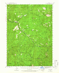
1944 Map of Tiller
USGS Topo · Published 1966About this map
Tiller sits at the junction of the South Fork Umpqua River and Elk Creek, serving as a central hub for the remote forest economy of Douglas and Jackson counties in the 1940s. The landscape is defined by its industrial and residential outposts, including the Tiller Ranger Station and various family-run homesteads like Marshall Place and Nichols Ranch. Education and timber processing are scattered throughout the drainages, evidenced by the Drew Sch and Tison Sch, as well as the Old Johnson Mill and the evocative Shangri-La Mill.
Find a feature on this map
103 named features on this map. Tap any name to fly to it.
Don’t see what you’re looking for? This feature index may not catch every label — zoom into the map to look around manually.
Map Details
Editions of this 1944 Tiller Map
5 editions found
Other maps of this area

1891 · Ashland
USGS Topo · 1:250,000

1893 · Ashland
USGS Topo · 1:250,000

1897 · Roseburg
USGS Topo · 1:125,000

1897 · Ashland
USGS Topo · 1:250,000

1900 · Roseburg
USGS Topo · 1:125,000

1904 · Riddle
USGS Topo · 1:125,000

1943 · Trail
USGS Topo · 1:62,500

1944 · Tiller
USGS Topo · 1:62,500

1944 · Abbott Butte
USGS Topo · 1:62,500

1947 · Abbott Butte
USGS Topo · 1:62,500