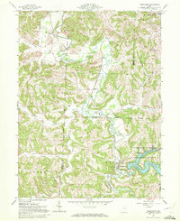
1961 Map of Tippecanoe
USGS Topo · Published 1972About this map
Clendening Reservoir dominates the southeastern corner of this Harrison County landscape, part of the Muskingum Watershed Conservancy District flood control system. The Baltimore and Ohio railroad corridor follows the winding course of Stillwater Creek, connecting the settlements of Newport and Tippecanoe. This survey reveals a landscape shaped by both early land grants—specifically the United States Military District and the Dohrman Grant Boundary—and industrial extraction, with numerous strip mines and Kilns active across the township lines. Remote community life is evidenced by family and local landmarks like Dutch Valley Cem, Pleasant Grove Ch, and the isolated Feed Springs. From the Clendening Dam to the northern reaches of Dutch Valley, the map captures the transition between rural valley farming and the emerging infrastructure of water management and coal recovery.
Find a feature on this map
46 named features on this map. Tap any name to fly to it.
Don’t see what you’re looking for? This feature index may not catch every label — zoom into the map to look around manually.
Map Details
Editions of this 1961 Tippecanoe Map
Other maps of this area

1902 · Scio
USGS Topo · 1:62,500

1903 · Flushing
USGS Topo · 1:62,500

1904 · Scio
USGS Topo · 1:62,500

1905 · Flushing
USGS Topo · 1:62,500

1909 · Antrim
USGS Topo · 1:48,000

1909 · Uhrichsville
USGS Topo · 1:62,500

1911 · Antrim
USGS Topo · 1:62,500

1911 · Uhrichsville
USGS Topo · 1:62,500

1951 · Canton
USGS Topo · 1:250,000

1953 · Canton
USGS Topo · 1:250,000