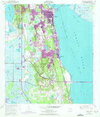
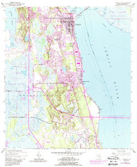
1949 Map of Titusville
USGS Topo · Published 1972About this map
Titusville and its surrounding coastal landscape are documented here during a period of transition as the space age began to reshape Brevard County. The map details the established settlement of Indian River City and smaller locales like Bellwood and Burns Hammock, while the encroaching infrastructure of the John F Kennedy Space Center (Nasa) appears to the northeast across Brock Flats. The landscape is a mix of older land divisions, notably the Delespine Grant, and mid-century developments such as Whispering Hills Golf Estates. Along the shoreline, the Intracoastal Waterway follows the expanse of the Indian River, connected to the mainland via the Nasa Parkway West Causeway. Local infrastructure like Titusville High School and Arthur Dunn Airpark serve the growing community, while the interior is defined by numerous water bodies including South Lake and Fox Lake.
Find a feature on this map
23 named features on this map. Tap any name to fly to it.
Don’t see what you’re looking for? This feature index may not catch every label — zoom into the map to look around manually.
Map Details
Editions of this 1949 Titusville Map
6 editions found
Other maps of this area

1949 · Orsino
USGS Topo · 1:24,000

1949 · Titusville
USGS Topo · 1:24,000

1949 · Courtenay
USGS Topo · 1:24,000

1949 · Wilson
USGS Topo · 1:24,000

1949 · Mims
USGS Topo · 1:24,000

1949 · Sharpes
USGS Topo · 1:24,000

1950 · Aurantia
USGS Topo · 1:24,000

1951 · Courtenay
USGS Topo · 1:24,000

1951 · Sharpes
USGS Topo · 1:24,000

1951 · Orsino
USGS Topo · 1:24,000
Featured Places
- Titusville, FL
- Whispering Hills Golf Estates, Titusville
- Indian River City, Titusville
- South Titusville, FL
- Bellwood, FL