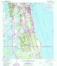
1949 Map of Titusville
USGS Topo · Published 1984About this map
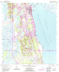
The Indian River shoreline serves as the primary axis for this Mid-century study, showcasing the development of Titusville and Indian River City during a transformative period of aerospace growth. To the east, the sprawling John F Kennedy Space Center (NASA) footprint indicates the massive regional shift toward space exploration, while the western landscape remains dominated by the St Johns National Wildlife Refuge and the intricate wetlands around South Lake. The transportation network is anchored by the Florida East Coast railway and the NASA Parkway West Causeway, bridging the mainland to the coastal flats. Local life is documented through suburban expansion at Whispering Hills Golf Estates and smaller settlements like Bellwood and Burns Hammock. The map preserves older land divisions such as the Delespine Grant, contrasting the area's colonial-era property lines with modern infrastructure like the Titusville Cocoa Airport.
Find a feature on this map
29 named features on this map. Tap any name to fly to it.
Don’t see what you’re looking for? This feature index may not catch every label — zoom into the map to look around manually.
Map Details
Editions of this 1949 Titusville Map
6 editions found
Other maps of this area

1949 · Orsino
USGS Topo · 1:24,000

1949 · Titusville
USGS Topo · 1:24,000

1949 · Courtenay
USGS Topo · 1:24,000

1949 · Wilson
USGS Topo · 1:24,000

1949 · Mims
USGS Topo · 1:24,000

1949 · Sharpes
USGS Topo · 1:24,000

1950 · Aurantia
USGS Topo · 1:24,000

1951 · Courtenay
USGS Topo · 1:24,000

1951 · Sharpes
USGS Topo · 1:24,000

1951 · Orsino
USGS Topo · 1:24,000
Featured Places
- Titusville, FL
- Whispering Hills Golf Estates, Titusville
- Indian River City, Titusville
- South Titusville, FL
- Bellwood, FL