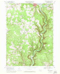
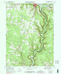
1968 Map of Titusville South
USGS Topo · Published 1971About this map
Oil Creek winds through the heart of this landscape, its steep valley floor serving as the historic corridor for the Penn Central railroad and the birthplace of the American petroleum industry. The legacy of the 19th-century oil boom is evident in the dense clusters of oil wells and extensive oil fields that dot the hillsides, particularly near Petroleum Center and Shamburg. Much of the northern terrain is preserved within Drake Well State Park, commemorating the site of the first successful commercial oil well. Away from the river, the map documents a rural landscape of family-named corners and small communities such as Breedtown, Miller Farm, and Gresham. The infrastructure of the late 1960s is also represented, from the Radio Tower (WTIV) to the Drive-in Theater near Titusville, alongside rural education sites like Cherrytree Sch.
Find a feature on this map
52 named features on this map. Tap any name to fly to it.
Don’t see what you’re looking for? This feature index may not catch every label — zoom into the map to look around manually.
Map Details
Editions of this 1968 Titusville South Map
5 editions found
Other maps of this area

1909 · Franklin
USGS Topo · 1:62,500

1911 · Franklin
USGS Topo · 1:62,500

1922 · Oil City
USGS Topo · 1:48,000

1924 · Oil City
USGS Topo · 1:62,500

1927 · Townville
USGS Topo · 1:48,000

1927 · Titusville
USGS Topo · 1:62,500

1932 · Townville
USGS Topo · 1:62,500

1933 · Titusville
USGS Topo · 1:62,500

1943 · Oil City
USGS Topo · 1:62,500

1945 · Townville
USGS Topo · 1:62,500
Featured Places
- Titusville, PA
- Cherrytree Township, PA
- Cornplanter Township, PA
- Petroleum Center, Cornplanter Township
- East Titusville, PA