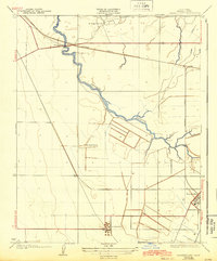
1924 Map of Tranquillity
USGS Topo · Published 1943About this map
Tranquillity and the surrounding agricultural basin of Fresno County appear here just after the first world war, anchored by a network of large ranch holdings and emerging industrial infrastructure. The landscape is defined by the winding course of the Fresno Slough, which dictates the placement of early crossings like Whites Bridge. Evidence of the region's diverse economic development is visible in the presence of the Oil Pumping Sta to the south and the Southern Pacific rail line cutting across the northern reaches near Ingle. Local family history is preserved through the mapping of specific property boundaries, including the Herminghaus Ranch, Borland Ranch, and Englebrecht Ranch. These sites reflect the early 20th-century transition of the San Joaquin Valley into a highly managed landscape of irrigation and transport.
Find a feature on this map
9 named features on this map. Tap any name to fly to it.
Don’t see what you’re looking for? This feature index may not catch every label — zoom into the map to look around manually.
Map Details
Editions of this 1924 Tranquillity Map
3 editions found
Other maps of this area

1921 · Mendota
USGS Topo · 1:31,680

1922 · Tufts Ranch
USGS Topo · 1:31,680

1923 · Levis
USGS Topo · 1:31,680

1923 · Englebrecht Ranch
USGS Topo · 1:31,680

1923 · Firebaugh
USGS Topo · 1:31,680

1924 · Jamesan
USGS Topo · 1:31,680

1924 · Tranquillity
USGS Topo · 1:31,680

1924 · Gravelly Ford
USGS Topo · 1:31,680

1924 · Mendota
USGS Topo · 1:31,680

1925 · San Joaquin
USGS Topo · 1:31,680