
1969 Map of Trenton
USGS Topo · Published 1971About this map
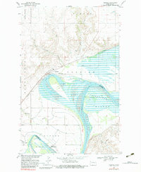
Trenton sits at the northern edge of a dynamic river landscape where the Missouri River meets the expansive reach of Lake Sakakawea. This late 1960s survey captures the area as the waters of the Garrison Diversion and the Oahe projects influenced the Missouri's course, creating prominent features like Lake Trenton and the surrounding Trenton Public Use Area. The Burlington Northern railroad cuts through the terrain, passing northern coulees such as Miller Coulee and Bobs Coulee.
Find a feature on this map
27 named features on this map. Tap any name to fly to it.
Don’t see what you’re looking for? This feature index may not catch every label — zoom into the map to look around manually.
Map Details
Editions of this 1969 Trenton Map
2 editions found
Other maps of this area

1953 · Williston
USGS Topo · 1:250,000

1953 · Watford City
USGS Topo · 1:250,000

1957 · Williston
USGS Topo · 1:250,000

1957 · Watford City
USGS Topo · 1:250,000

1959 · Williston West
USGS Topo · 1:24,000

1967 · Watford City
USGS Topo · 1:250,000

1968 · Trenton SW
USGS Topo · 1:24,000
1968 · Buford
USGS Topo · 1:24,000

1969 · Cartwright NE
USGS Topo · 1:24,000

1974 · Trenton NE
USGS Topo · 1:24,000