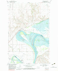
1969 Map of Trenton
USGS Topo · Published 1983About this map
Lake Sakakawea dominates the landscape south of the high bluffs in this 1960s study of the Missouri River valley. The map documents the complex water management infrastructure along the northern shore, including the Lake Trenton Pumping Sta and several siphons that served the local agricultural system. The small settlement of Trenton sits at a strategic junction where the Burlington Northern railroad tracks parallel the curves of Lake Trenton. South of the river, the terrain rises toward the heights of Crow Fly High Hill and the plains of Elk. The presence of numerous gravel pits along the rail line and riverbanks indicates the active extraction of local resources during this era. Land use transitions from the riparian wetlands near Painted Woods Creek to the named upland prairies of Round Prairie and Judson.
Find a feature on this map
35 named features on this map. Tap any name to fly to it.
Don’t see what you’re looking for? This feature index may not catch every label — zoom into the map to look around manually.
Map Details
Editions of this 1969 Trenton Map
2 editions found
Other maps of this area

1953 · Williston
USGS Topo · 1:250,000

1953 · Watford City
USGS Topo · 1:250,000

1957 · Williston
USGS Topo · 1:250,000

1957 · Watford City
USGS Topo · 1:250,000

1959 · Williston West
USGS Topo · 1:24,000

1967 · Watford City
USGS Topo · 1:250,000

1968 · Trenton SW
USGS Topo · 1:24,000
1968 · Buford
USGS Topo · 1:24,000

1969 · Trenton
USGS Topo · 1:24,000

1969 · Cartwright NE
USGS Topo · 1:24,000