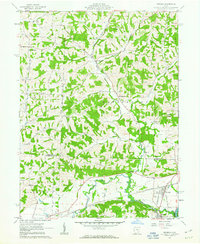
1962 Map of Trinway
USGS Topo · Published 1963About this map
Wakatomika Creek carves a deep valley through the hills of the United States Military District, anchoring a landscape defined by small rural settlements and evolving transport networks in the early 1960s. The village of Trinway serves as a vital rail junction where the Pennsylvania and N Y C & ST L RR lines meet near the banks of the Muskingum River. This topography reveals the transition from rail-dependent industry to modern surface extraction, as seen in the scattered Strip Mine operations and a decommissioned Old Railroad Grade winding through Washington township. Local genealogy is well-preserved through numerous small burying grounds like Broomstick Cem and Cody Cem, alongside country congregations at Union Ch and Chalfant Ch. The rugged terrain of Graham Ridge and Irish Ridge separates these early communities, maintaining the distinct identities of West Carlisle and Cooperdale.
Find a feature on this map
36 named features on this map. Tap any name to fly to it.
Don’t see what you’re looking for? This feature index may not catch every label — zoom into the map to look around manually.
Map Details
Editions of this 1962 Trinway Map
4 editions found
Other maps of this area

1908 · Conesville
USGS Topo · 1:62,500

1910 · Frazeysburg
USGS Topo · 1:62,500

1910 · Conesville
USGS Topo · 1:62,500

1913 · Brinkhaven
USGS Topo · 1:62,500

1913 · Coshocton
USGS Topo · 1:62,500

1915 · Brinkhaven
USGS Topo · 1:62,500

1915 · Coshocton
USGS Topo · 1:62,500

1943 · Coshocton
USGS Topo · 1:62,500

1950 · Marion
USGS Topo · 1:250,000

1951 · Canton
USGS Topo · 1:250,000