1957 Map of Trona
USGS Topo · Published 1967About this map
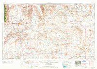
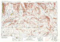
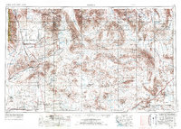
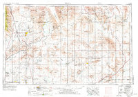
Searles Lake and the industrial settlement of Trona anchor this mid-century look at the high desert, where mining operations and military testing grounds dominate the landscape. The map details a complex extraction economy, from the Borax Mine near Boron to a cluster of historic mining sites in the Panamint Range and Slate Range, including the Saratoga and War Eagle mines. Infrastructure of the era is clearly visible, including the Trona Railway and the corridor of the Tidewater and Tonopah.
Find a feature on this map
177 named features on this map. Tap any name to fly to it.
Don’t see what you’re looking for? This feature index may not catch every label — zoom into the map to look around manually.
Map Details
Editions of this 1957 Trona Map
5 editions found

Other maps of this area

1903 · Randsburg
USGS Topo · 1:62,500

1905 · Olancha
USGS Topo · 1:125,000

1906 · Kernville
USGS Topo · 1:125,000

1907 · Olancha
USGS Topo · 1:125,000

1907 · Las Vegas
USGS Topo · 1:250,000

1908 · Furnace Creek
USGS Topo · 1:250,000

1908 · Las Vegas
USGS Topo · 1:250,000

1908 · Kernville
USGS Topo · 1:125,000

1908 · Ballarat
USGS Topo · 1:250,000

1910 · Furnace Creek
USGS Topo · 1:250,000