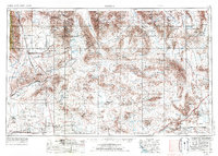
1957 Map of Trona
USGS Topo · Published 1976About this map
Searles Lake and the industrial settlements of Trona, Argus, and Westend anchor this high-desert study during a period of significant military and mineral expansion. The landscape is defined by its massive salt pans and the expansive boundaries of the US Naval Weapons Center and the Fort Irwin Military Reservation. Mining operations are prolific across the desert ranges, including the Gold Bottom Mine and Monarch Mine in the north, and the Superior Mine to the south.
Find a feature on this map
66 named features on this map. Tap any name to fly to it.
Don’t see what you’re looking for? This feature index may not catch every label — zoom into the map to look around manually.
Map Details
Editions of this 1957 Trona Map
5 editions found

Other maps of this area

1903 · Randsburg
USGS Topo · 1:62,500

1905 · Olancha
USGS Topo · 1:125,000

1906 · Kernville
USGS Topo · 1:125,000

1907 · Olancha
USGS Topo · 1:125,000

1907 · Las Vegas
USGS Topo · 1:250,000

1908 · Furnace Creek
USGS Topo · 1:250,000

1908 · Las Vegas
USGS Topo · 1:250,000

1908 · Kernville
USGS Topo · 1:125,000

1908 · Ballarat
USGS Topo · 1:250,000

1910 · Furnace Creek
USGS Topo · 1:250,000