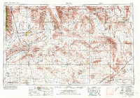
1957 Map of Trona
USGS Topo · Published 1973About this map
Searles Lake and the industrial settlement of Trona dominate this mid-century landscape where potash and mineral extraction meet the high desert. The map captures a transitional era for the northern Mojave Desert, showing the established mining communities of Johannesburg and Red Mountain alongside the growth of Ridgecrest. Significant military and scientific presence is evident through the US Naval Weapons Center and NAF China Lake, while the eastern portion of the sheet documents the remote reaches of Death Valley National Monument. Local mineral history is visible in the placement of the Kelly Mine and Gold Bottom Mine, as well as the specialized transport networks of the Southern Pacific and Atchison Topeka and Santa Fe railroads which serviced the region's boron and salt works.
Find a feature on this map
63 named features on this map. Tap any name to fly to it.
Don’t see what you’re looking for? This feature index may not catch every label — zoom into the map to look around manually.
Map Details
Editions of this 1957 Trona Map
5 editions found

Other maps of this area

1903 · Randsburg
USGS Topo · 1:62,500

1905 · Olancha
USGS Topo · 1:125,000

1906 · Kernville
USGS Topo · 1:125,000

1907 · Olancha
USGS Topo · 1:125,000

1907 · Las Vegas
USGS Topo · 1:250,000

1908 · Furnace Creek
USGS Topo · 1:250,000

1908 · Las Vegas
USGS Topo · 1:250,000

1908 · Kernville
USGS Topo · 1:125,000

1908 · Ballarat
USGS Topo · 1:250,000

1910 · Furnace Creek
USGS Topo · 1:250,000