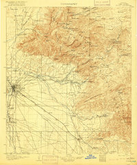
1905 Map of Tucson
USGS Topo · Published 1916About this map
The high desert basin of Tucson serves as the hub for this early century landscape, where the Southern Pacific railroad cuts a diagonal line toward the southeast through Wilmot and Esmond. To the north, the massive uplift of the Santa Catalina Mountains dominates the view, dotted with seasonal and industrial outposts like Catalina Camp, Soldiers Camp, and a Sawmill near Webbers Cabin. The map details a transition from urban development to a rugged ranching and mining economy, evidenced by family-named holdings such as Pusch's Steampump and the Agua Caliente Ranch.
Find a feature on this map
99 named features on this map. Tap any name to fly to it.
Don’t see what you’re looking for? This feature index may not catch every label — zoom into the map to look around manually.
Map Details
Editions of this 1905 Tucson Map
5 editions found
Other maps of this area

1904 · Patagonia
USGS Topo · 1:125,000

1904 · Tucson
USGS Topo · 1:125,000

1905 · Patagonia
USGS Topo · 1:125,000

1905 · Tucson
USGS Topo · 1:125,000

1911 · Winkelman
USGS Topo · 1:125,000

1913 · Winkelman
USGS Topo · 1:125,000

1915 · Benson
USGS Topo · 1:125,000

1920 · Arivaca
USGS Topo · 1:125,000

1925 · Samaniego Peak
USGS Topo · 1:62,500

1925 · San Xavier
USGS Topo · 1:62,500