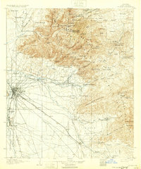
1905 Map of Tucson
USGS Topo · Published 1932About this map
Tucson serves as the central hub for this early century landscape, radiating rail lines and primitive roads toward the mountain ranges that define the horizon. The city sits at the confluence of the Santa Cruz River and Rillito, with the Southern Pacific railroad cutting a sharp diagonal through the valley toward Wilmot and Esmond. To the northeast, the Santa Catalina Mountains are peppered with high-altitude outposts like Summerhaven Cabin and Soldiers Camp, alongside numerous named mines and camps including Keystone Camp and Donovans Camp.
Find a feature on this map
113 named features on this map. Tap any name to fly to it.
Don’t see what you’re looking for? This feature index may not catch every label — zoom into the map to look around manually.
Map Details
Editions of this 1905 Tucson Map
5 editions found
Other maps of this area

1904 · Patagonia
USGS Topo · 1:125,000

1904 · Tucson
USGS Topo · 1:125,000

1905 · Patagonia
USGS Topo · 1:125,000

1905 · Tucson
USGS Topo · 1:125,000

1911 · Winkelman
USGS Topo · 1:125,000

1913 · Winkelman
USGS Topo · 1:125,000

1915 · Benson
USGS Topo · 1:125,000

1920 · Arivaca
USGS Topo · 1:125,000

1925 · Samaniego Peak
USGS Topo · 1:62,500

1925 · San Xavier
USGS Topo · 1:62,500