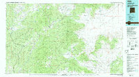
1983 Map of Tularosa Mountains
USGS Topo · Published 1983About this map
Gila National Forest and Apache National Forest dominate this high-altitude landscape in western New Mexico, where the Continental Divide winds through the Tularosa Mountains and Mangas Mountains. The topography is defined by sharp peaks like Eagle Peak and Milligan Mountain, while the northeast corner opens into the broad Plains of San Agustin. Settlement centers on the valley of the San Francisco River, which links the village of Reserve with San Francisco Plaza and Lower San Francisco Plaza. Remote outposts such as Old Horse Springs and the Negrito Airstrip illustrate the sparse, high-desert character of Catron County in the early 1980s. The convergence of the Tularosa River and various creeks like Negrito Creek shows the critical role of water in this arid mountain environment.
Find a feature on this map
44 named features on this map. Tap any name to fly to it.
Don’t see what you’re looking for? This feature index may not catch every label — zoom into the map to look around manually.
Map Details
Editions of this 1983 Tularosa Mountains Map
2 editions found
Other maps of this area

1886 · St Johns
USGS Topo · 1:250,000

1892 · St Johns
USGS Topo · 1:250,000

1910 · Mogollon
USGS Topo · 1:125,000

1911 · Alum Mountain
USGS Topo · 1:125,000

1912 · Mogollon
USGS Topo · 1:125,000

1913 · Alum Mountain
USGS Topo · 1:125,000

1913 · Morenci
USGS Topo · 1:125,000

1915 · Morenci
USGS Topo · 1:125,000

1915 · Reserve
USGS Topo · 1:125,000

1918 · Pelona
USGS Topo · 1:125,000