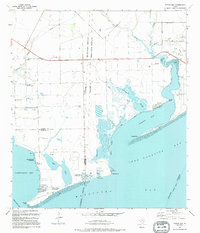
1995 Map of Turtle Bay
USGS Topo · Published 1995About this map
Tres Palacios Bay and Turtle Bay define this coastal landscape where Jackson, Matagorda, and Calhoun counties meet. The shoreline is marked by distinct settlements like the Schicke Point Community and El Campo Club Community, while the interior shows the transition from ranching to specialized aquaculture. Coastal industry is evidenced by a Marine Fisheries Research Station, alongside a dedicated Shrimp Farm and Fish Farm near the marshes.
Find a feature on this map
36 named features on this map. Tap any name to fly to it.
Don’t see what you’re looking for? This feature index may not catch every label — zoom into the map to look around manually.
Map Details
Editions of this 1995 Turtle Bay Map
This is the sole edition of this map. No revisions or reprints were ever made.
Other maps of this area

1951 · Keller Bay
USGS Topo · 1:24,000

1952 · Palacios Point
USGS Topo · 1:24,000

1952 · Palacios
USGS Topo · 1:24,000

1952 · Olivia
USGS Topo · 1:24,000

1952 · Turtle Bay
USGS Topo · 1:24,000

1952 · Francitas
USGS Topo · 1:24,000

1952 · Blessing
USGS Topo · 1:24,000

1952 · La Ward
USGS Topo · 1:24,000

1953 · Beeville
USGS Topo · 1:250,000

1956 · Beeville
USGS Topo · 1:250,000
Featured Places
- Palacios, TX
- Schicke Point Community, TX
- El Campo Club Community, TX
- Matagorda County, TX
- Calhoun County, TX