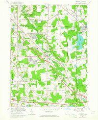
1963 Map of Twinsburg
USGS Topo · Published 1964About this map
Tinkers Creek carves a deep valley through this 1963 landscape, serving as a focal point for the developing communities of Twinsburg and Solon. The map documents a period of significant suburban expansion, evident in the residential layouts of Western Reserve Estates and the proximity of institutional sites like the Cleveland Boys Sch. To the northeast, the Amusement Park at Geauga Lake stands as a major regional landmark, while the New York Chicago and St Louis and Erie-Lackawanna railroads maintain their historical transport corridors. Rural remnants persist in the form of the Crown Hill Cemetery and Markillie Cem, alongside educational hubs like Chamberlin High Sch. The intersection of the Ohio Toll Road and the Pennsylvania rail line further highlights the area's role as a transit nexus between Cleveland and Akron.
Find a feature on this map
63 named features on this map. Tap any name to fly to it.
Don’t see what you’re looking for? This feature index may not catch every label — zoom into the map to look around manually.
Map Details
Editions of this 1963 Twinsburg Map
4 editions found
Other maps of this area

1903 · Cleveland
USGS Topo · 1:62,500

1903 · Akron
USGS Topo · 1:62,500

1905 · Akron
USGS Topo · 1:62,500

1906 · Kent
USGS Topo · 1:62,500

1906 · Chagrin Falls
USGS Topo · 1:62,500

1908 · Chagrin Falls
USGS Topo · 1:62,500

1950 · Cleveland
USGS Topo · 1:250,000

1953 · South Russell
USGS Topo · 1:24,000

1953 · Aurora
USGS Topo · 1:24,000

1953 · Chagrin Falls
USGS Topo · 1:24,000