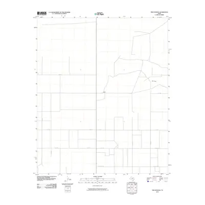
2010 Map of Two B Ranch
USGS Topo · Published 2010About this map
Two B Ranch anchors this portion of Yoakum County, sitting at a quiet crossroads in the high plains of West Texas. The landscape is defined by its agricultural and ranching grid, with an extensive network of county roads like Co Rd 150 and Co Rd 120 cutting through the flat terrain. The most significant natural feature is Lost Draw, a shallow ephemeral drainage that winds through the northeastern quadrant, serving as a rare break in the geometric regularity of the land. This 2010 survey illustrates the remote character of the region, where the naming of thoroughfares such as Six Mile Rd and Cherkee Strip Rd reflects the utilitarian and frontier history of the Llano Estacado. The map serves as a record of rural land divisions and the persistent ranching operations that have shaped the county's identity into the 21st century.
Find a feature on this map
12 named features on this map. Tap any name to fly to it.
Don’t see what you’re looking for? This feature index may not catch every label — zoom into the map to look around manually.
Map Details
Editions of this 2010 Two B Ranch Map
This is the sole edition of this map. No revisions or reprints were ever made.
Other maps of this area

1954 · Brownfield
USGS Topo · 1:250,000

1958 · Brownfield
USGS Topo · 1:250,000

1962 · Brownfield
USGS Topo · 1:250,000

1970 · Plains 1 SW
USGS Topo · 1:24,000

1970 · Tokio NW
USGS Topo · 1:24,000

1970 · Plains 1 NW
USGS Topo · 1:24,000

1971 · Plains NW
USGS Topo · 1:24,000

1971 · Schooler Ranch
USGS Topo · 1:24,000
1971 · Plains
USGS Topo · 1:24,000
1971 · Two B Ranch
USGS Topo · 1:24,000