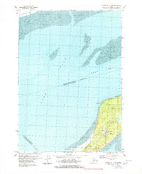
1979 Map of Tyonek A-1 NW
USGS Topo · Published 1980About this map
Cook Inlet dominates this 1970s hydrographic and topographic study, showing the convergence of the Knik Arm and Turnagain Arm near the Matanuska-Susitna Borough and Municipality of Anchorage boundary. The northern tip of Fire Island is the primary terrestrial focus, serving as a critical infrastructure hub for the region. Beyond the tidally influenced Mud flats of the Susitna Flats, the island contains a concentration of aviation and communication assets, including an FAA Facility, a Radio Facility, and a Heliport. The landscape reveals a mix of utilitarian and recreational use, with a Ski Tow and Picnic Area located near Shelter Bay. Navigational aids like the Race Point Lights at Race Point underscore the island's role in guiding maritime traffic through these complex Alaskan waterways.
Find a feature on this map
17 named features on this map. Tap any name to fly to it.
Don’t see what you’re looking for? This feature index may not catch every label — zoom into the map to look around manually.
Map Details
Editions of this 1979 Tyonek A-1 NW Map
2 editions found
Other maps of this area

1949 · Tyonek
USGS Topo · 1:250,000

1951 · Tyonek
USGS Topo · 1:250,000

1951 · Tyonek A-2
USGS Topo · 1:63,360

1951 · Tyonek A-1
USGS Topo · 1:63,360

1952 · Tyonek A-2
USGS Topo · 1:63,360

1952 · Tyonek A-1
USGS Topo · 1:63,360

1958 · Tyonek B-1
USGS Topo · 1:63,360

1958 · Tyonek B-2
USGS Topo · 1:63,360

1958 · Tyonek
USGS Topo · 1:250,000

1965 · Tyonek
USGS Topo · 1:250,000