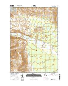
2016 Map of Tyonek A-6 NE
USGS Topo · Published 2016About this map
The Chakachatna River carves a broad alluvial path through this corner of the Kenai Peninsula, flanked by the northern reaches of the Neacola Mountains. This terrain is defined by the braided water systems and glacial features characteristic of south-central Alaska, including the distinct Ch'atanaltch'et Li'a glacier in the northwest. The presence of Straight Creek cutting across the northern sections illustrates the complex drainage patterns feeding into the larger river valley. In this 2016 survey, the land remains largely undeveloped, showcasing the raw geological forms of the public land survey system blocks like t13n r16w and t13n r15w, where natural topography dictates the movement of water and the shape of the mountain slopes.
Find a feature on this map
8 named features on this map. Tap any name to fly to it.
Don’t see what you’re looking for? This feature index may not catch every label — zoom into the map to look around manually.
Map Details
Editions of this 2016 Tyonek A-6 NE Map
This is the sole edition of this map. No revisions or reprints were ever made.
Other maps of this area

1949 · Tyonek
USGS Topo · 1:250,000

1951 · Tyonek
USGS Topo · 1:250,000

1958 · Tyonek A-6
USGS Topo · 1:63,360

1958 · Tyonek A-5
USGS Topo · 1:63,360

1958 · Tyonek B-5
USGS Topo · 1:63,360

1958 · Tyonek B-6
USGS Topo · 1:63,360

1958 · Tyonek
USGS Topo · 1:250,000
1959 · Tyonek A-6
USGS Topo · 1:63,360

1965 · Tyonek
USGS Topo · 1:250,000
2013 · Tyonek A-5 NW
USGS Topo · 1:25,000