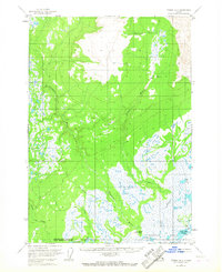
1958 Map of Tyonek B-3
USGS Topo · Published 1967About this map
The Beluga River and Theodore River dominate this 1950s landscape, winding through a complex network of wetlands and upland drainages. The map reveals a remote, resource-oriented terrain where aviation and subsistence provided the primary means of access. The presence of a Winter Landing Strip and a Mine suggest seasonal industrial activity, while isolated outposts like Grants Cabin and other scattered cabins indicate a sparse, localized human footprint.
Find a feature on this map
14 named features on this map. Tap any name to fly to it.
Don’t see what you’re looking for? This feature index may not catch every label — zoom into the map to look around manually.
Map Details
Editions of this 1958 Tyonek B-3 Map
3 editions found
Other maps of this area

1949 · Tyonek
USGS Topo · 1:250,000

1951 · Tyonek
USGS Topo · 1:250,000

1951 · Tyonek A-2
USGS Topo · 1:63,360

1952 · Tyonek A-2
USGS Topo · 1:63,360

1954 · Tyonek C-4
USGS Topo · 1:63,360

1954 · Tyonek B-4
USGS Topo · 1:63,360

1954 · Tyonek C-3
USGS Topo · 1:63,360

1958 · Tyonek C-2
USGS Topo · 1:63,360

1958 · Tyonek B-3
USGS Topo · 1:63,360

1958 · Tyonek A-4
USGS Topo · 1:63,360