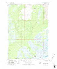
1958 Map of Tyonek B-3
USGS Topo · Published 1987About this map
Theodore River and the Lewis River dominate this 1958 survey of the Alaskan wilderness, carving through the lowlands where the Matanuska-Susitna and Kenai Peninsula Borough boundaries meet. The map documents an era of early resource exploration and remote subsistence, marked by numerous Drill Holes and isolated structures like Grants Cabin. The drainage network is dense, including Pretty Creek, the Chedatna River, and the Ivan River which feeds into the Ivan Lakes. Evidence of seasonal transport and industry is visible at the Winter Landing Strip and a solitary Mine in the northern highlands. The landscape transitions from the higher elevations of Wolverine Creek down to the broad marshes of the Beluga River and the tidal influence of the Lewis River Slough, illustrating a complex hydrologic system before major modern development.
Find a feature on this map
21 named features on this map. Tap any name to fly to it.
Don’t see what you’re looking for? This feature index may not catch every label — zoom into the map to look around manually.
Map Details
Editions of this 1958 Tyonek B-3 Map
3 editions found
Other maps of this area

1949 · Tyonek
USGS Topo · 1:250,000

1951 · Tyonek
USGS Topo · 1:250,000

1951 · Tyonek A-2
USGS Topo · 1:63,360

1952 · Tyonek A-2
USGS Topo · 1:63,360

1954 · Tyonek C-4
USGS Topo · 1:63,360

1954 · Tyonek B-4
USGS Topo · 1:63,360

1954 · Tyonek C-3
USGS Topo · 1:63,360

1958 · Tyonek C-2
USGS Topo · 1:63,360

1958 · Tyonek B-3
USGS Topo · 1:63,360

1958 · Tyonek A-4
USGS Topo · 1:63,360