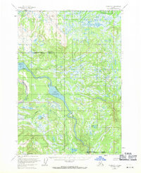
1954 Map of Tyonek B-4
USGS Topo · Published 1971About this map
The Beluga River drainage dominates this mid-century look at the Alaskan wilderness, where the Matanuska-Susitna Borough meets the Kenai Peninsula Borough. The landscape is defined by an intricate network of waterways, featuring the expansive Beluga Lake and Lower Beluga Lake. These bodies of water are fed by glacial and mountain runoff from tributaries like Drill Creek, Bishop Creek, and the Chichantna River.
Find a feature on this map
16 named features on this map. Tap any name to fly to it.
Don’t see what you’re looking for? This feature index may not catch every label — zoom into the map to look around manually.
Map Details
Editions of this 1954 Tyonek B-4 Map
4 editions found
Other maps of this area

1949 · Tyonek
USGS Topo · 1:250,000

1951 · Tyonek
USGS Topo · 1:250,000

1954 · Tyonek C-5
USGS Topo · 1:63,360

1954 · Tyonek C-4
USGS Topo · 1:63,360

1954 · Tyonek B-4
USGS Topo · 1:63,360

1954 · Tyonek C-3
USGS Topo · 1:63,360

1958 · Tyonek A-5
USGS Topo · 1:63,360

1958 · Tyonek B-3
USGS Topo · 1:63,360

1958 · Tyonek A-4
USGS Topo · 1:63,360
1958 · Tyonek A-3
USGS Topo · 1:63,360