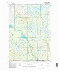
1954 Map of Tyonek B-4
USGS Topo · Published 1981About this map
Lower Beluga Lake and its primary outflow, the Beluga River, dominate this mid-century survey of the wilderness north of Cook Inlet. The landscape is defined by a dense network of wetlands and small glacial lakes, including Bishop Lake, Carlson Lake, and Felt Lake. The boundary between the Matanuska-Susitna Borough and Kenai Peninsula Borough bisects the area, following the natural course of the water. High points such as Lone Ridge and the VABM Akitty survey marker provide relief in an otherwise low-lying area. Aside from a few scattered structures like a Cabin and the presence of Drill Creek, the territory remains largely undeveloped, showcasing the complex river systems of the Chichantna River and Talachulitna River before the onset of modern industrial infrastructure.
Find a feature on this map
17 named features on this map. Tap any name to fly to it.
Don’t see what you’re looking for? This feature index may not catch every label — zoom into the map to look around manually.
Map Details
Editions of this 1954 Tyonek B-4 Map
4 editions found
Other maps of this area

1949 · Tyonek
USGS Topo · 1:250,000

1951 · Tyonek
USGS Topo · 1:250,000

1954 · Tyonek C-5
USGS Topo · 1:63,360

1954 · Tyonek C-4
USGS Topo · 1:63,360

1954 · Tyonek B-4
USGS Topo · 1:63,360

1954 · Tyonek C-3
USGS Topo · 1:63,360

1958 · Tyonek A-5
USGS Topo · 1:63,360

1958 · Tyonek B-3
USGS Topo · 1:63,360

1958 · Tyonek A-4
USGS Topo · 1:63,360
1958 · Tyonek A-3
USGS Topo · 1:63,360