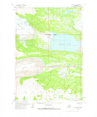
1958 Map of Tyonek B-5
USGS Topo · Published 1971About this map
Beluga Lake dominates the central landscape of this wilderness region, marking a significant hydrological divide at the border of the Matanuska-Susitna Borough and the Kenai Peninsula Borough. Massive ice fields, including the Triumvirate Glacier and Capps Glacier, define the western edge of the terrain, with numerous Crevasses noted across their frozen surfaces. The map documents a complex network of glacial runoff and mountain streams, where the Chichantna River and Coal Creek drain toward the lowlands. The presence of Strandline Lake and Coal Creek Lake in the north suggests the dynamic nature of these glacial margins during the mid-century. While largely devoid of permanent human settlements, the survey provides a precise record of the natural topography and unsurveyed land lines predetermined by the Bureau of Land Management.
Find a feature on this map
16 named features on this map. Tap any name to fly to it.
Don’t see what you’re looking for? This feature index may not catch every label — zoom into the map to look around manually.
Map Details
Editions of this 1958 Tyonek B-5 Map
2 editions found
Other maps of this area

1949 · Tyonek
USGS Topo · 1:250,000

1951 · Tyonek
USGS Topo · 1:250,000

1954 · Tyonek C-5
USGS Topo · 1:63,360

1954 · Tyonek C-4
USGS Topo · 1:63,360

1954 · Tyonek B-4
USGS Topo · 1:63,360

1958 · Tyonek A-6
USGS Topo · 1:63,360

1958 · Tyonek A-5
USGS Topo · 1:63,360

1958 · Tyonek A-4
USGS Topo · 1:63,360

1958 · Tyonek C-6
USGS Topo · 1:63,360

1958 · Tyonek B-5
USGS Topo · 1:63,360