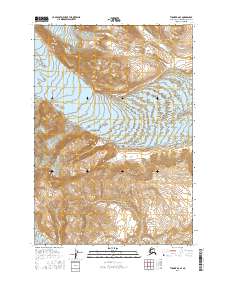
2016 Map of Tyonek B-6 SE
USGS Topo · Published 2016About this map
Dogshead Glacier and Capps Glacier dominate the upper elevations of this terrain in the Kenai Peninsula borough. These massive ice features are defined by intricate contour lines that illustrate the high-relief mountain environment, where glacial flow has carved deep troughs through the landscape. Near the southern boundary of the sheet, the label Ch'atanalt'elt marks a significant water feature, likely representing an indigenous place name for a water body or drainage in this glaciated region. The map also delineates the Public Land Survey System grid, including boundaries for t14n r15w and t15n r15w, which provide a framework for locating specific tracts of land within this wilderness area. The absence of roads or settlements emphasizes the remote nature of these mountain peaks and ice fields.
Find a feature on this map
11 named features on this map. Tap any name to fly to it.
Don’t see what you’re looking for? This feature index may not catch every label — zoom into the map to look around manually.
Map Details
Editions of this 2016 Tyonek B-6 SE Map
This is the sole edition of this map. No revisions or reprints were ever made.
Other maps of this area

1949 · Tyonek
USGS Topo · 1:250,000

1951 · Tyonek
USGS Topo · 1:250,000

1958 · Tyonek A-6
USGS Topo · 1:63,360

1958 · Tyonek A-5
USGS Topo · 1:63,360

1958 · Tyonek B-5
USGS Topo · 1:63,360

1958 · Tyonek B-6
USGS Topo · 1:63,360

1958 · Tyonek
USGS Topo · 1:250,000
1959 · Tyonek A-6
USGS Topo · 1:63,360

1965 · Tyonek
USGS Topo · 1:250,000
2013 · Tyonek A-5 NW
USGS Topo · 1:25,000