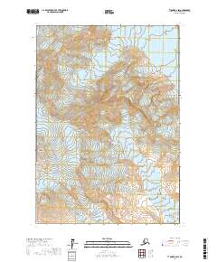
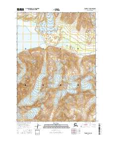
2017 Map of Tyonek B-6 SW
USGS Topo · Published 2017About this map
Mt Spurr dominates this high-altitude landscape within the Tordrillo Mountains, providing a detailed view of active volcanic and glacial systems. The topography is defined by the sharp elevations of Crater Peak and the surrounding ice fields, including Crater Glacier to the south and the sprawling Capps Glacier in the northeast. Of particular interest to those studying indigenous place names is the dual labeling of Chatanalch’elt Li’a, appearing alongside the larger glacial systems. This 2017 survey by the U.S. Geological Survey captures the complex ice and rock formations of the Kenai Peninsula Borough, including distinctive ridges like The Rowel. The map focuses entirely on the natural environment, showing a region devoid of human structures or roads, where the shifting margins of glaciers and high peaks are the only landmarks.
Find a feature on this map
13 named features on this map. Tap any name to fly to it.
Don’t see what you’re looking for? This feature index may not catch every label — zoom into the map to look around manually.
Map Details
Editions of this 2017 Tyonek B-6 SW Map
This is the sole edition of this map. No revisions or reprints were ever made.
Other maps of this area

1949 · Tyonek
USGS Topo · 1:250,000

1951 · Tyonek
USGS Topo · 1:250,000

1958 · Tyonek A-6
USGS Topo · 1:63,360

1958 · Tyonek B-6
USGS Topo · 1:63,360

1958 · Tyonek
USGS Topo · 1:250,000
1958 · Tyonek B-7
USGS Topo · 1:63,360
1958 · Tyonek A-7
USGS Topo · 1:63,360
1959 · Tyonek A-6
USGS Topo · 1:63,360

1965 · Tyonek
USGS Topo · 1:250,000
2016 · Tyonek A-7 NE
USGS Topo · 1:25,000