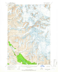
1958 Map of Tyonek B-7
USGS Topo · Published 1965About this map
Mount Torbert and Mount Spurr anchor this high-altitude Alaskan landscape, where massive ice fields dominate the topography of the Tordrillo Mountains. The survey, field-checked in the late 1950s, reveals a complex network of moving ice, including the expansive North Twin Glacier and South Twin Glacier to the north. These glaciers feed the lower elevations where the Nagishlamina River begins its course through a distinct valley of vegetation. The map provides a remarkable record of glacial extent and features like the Barrier Glacier and Pothole Glacier before modern climactic shifts. This is a wilderness defined by ice and elevation, capturing the precise contours of summits and crevasses in an era when much of this land remained unsurveyed by traditional ground methods.
Find a feature on this map
8 named features on this map. Tap any name to fly to it.
Don’t see what you’re looking for? This feature index may not catch every label — zoom into the map to look around manually.
Map Details
Editions of this 1958 Tyonek B-7 Map
2 editions found

Other maps of this area

1949 · Tyonek
USGS Topo · 1:250,000

1951 · Tyonek
USGS Topo · 1:250,000

1958 · Tyonek A-6
USGS Topo · 1:63,360

1958 · Tyonek C-6
USGS Topo · 1:63,360

1958 · Tyonek B-6
USGS Topo · 1:63,360

1958 · Tyonek B-8
USGS Topo · 1:63,360

1958 · Tyonek C-8
USGS Topo · 1:63,360

1958 · Tyonek
USGS Topo · 1:250,000

1958 · Tyonek A-8
USGS Topo · 1:63,360
1958 · Tyonek A-7
USGS Topo · 1:63,360