
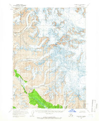
1958 Map of Tyonek B-7
USGS Topo · Published 1977About this map
Mount Spurr and Mount Torbert anchor this high-altitude landscape within the Kenai Peninsula and Matanuska-Susitna Boroughs. The 1958 survey documents a region dominated by massive ice fields and active glacial movement, with the North Twin Glacier and South Twin Glacier defining the northwestern sector. The topography is characterized by vast systems of crevasses that mark the surfaces of the Harpoon Glacier and Pothole Glacier. In the south, the Nagishlamina River cuts through the glacial outwash, while the Barrier Glacier creates a formidable wall of ice. This map captures a pristine glaciated environment in the mid-20th century, showing the intricate relationship between high mountain peaks and the river systems they feed.
Find a feature on this map
10 named features on this map. Tap any name to fly to it.
Don’t see what you’re looking for? This feature index may not catch every label — zoom into the map to look around manually.
Map Details
Editions of this 1958 Tyonek B-7 Map
2 editions found
Other maps of this area

1949 · Tyonek
USGS Topo · 1:250,000

1951 · Tyonek
USGS Topo · 1:250,000

1958 · Tyonek A-6
USGS Topo · 1:63,360

1958 · Tyonek C-6
USGS Topo · 1:63,360

1958 · Tyonek B-6
USGS Topo · 1:63,360

1958 · Tyonek B-8
USGS Topo · 1:63,360

1958 · Tyonek C-8
USGS Topo · 1:63,360

1958 · Tyonek
USGS Topo · 1:250,000

1958 · Tyonek A-8
USGS Topo · 1:63,360
1958 · Tyonek B-7
USGS Topo · 1:63,360