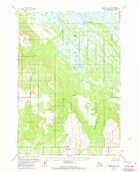
1954 Map of Tyonek C-3
USGS Topo · Published 1968About this map
Little Mt Susitna and the foothills of Beluga Mountain anchor this 1950s landscape, a region defined by an intricate network of wetlands and glacial runoff in the Matanuska-Susitna Borough. The drainage patterns are dominated by Alexander Creek and the meandering Toms Creek, which flow through a vast system of muskeg and small lakes. Human presence is sparse, marked primarily by isolated Cabins and a Landing Strip near Alexander Lake, indicating a reliance on bush planes for access during this era.
Find a feature on this map
21 named features on this map. Tap any name to fly to it.
Don’t see what you’re looking for? This feature index may not catch every label — zoom into the map to look around manually.
Map Details
Editions of this 1954 Tyonek C-3 Map
3 editions found
Other maps of this area

1949 · Tyonek
USGS Topo · 1:250,000

1951 · Tyonek
USGS Topo · 1:250,000

1954 · Tyonek D-2
USGS Topo · 1:63,360

1954 · Tyonek D-3
USGS Topo · 1:63,360

1954 · Tyonek C-4
USGS Topo · 1:63,360

1954 · Tyonek B-4
USGS Topo · 1:63,360

1954 · Tyonek D-4
USGS Topo · 1:63,360

1954 · Tyonek C-3
USGS Topo · 1:63,360

1958 · Tyonek C-2
USGS Topo · 1:63,360

1958 · Tyonek B-3
USGS Topo · 1:63,360