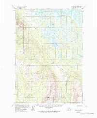
1954 Map of Tyonek C-3
USGS Topo · Published 1968About this map
Little Mt Susitna and Beluga Mountain anchor this mid-century topographic survey of the Alaskan interior, showing a landscape defined by an intricate network of waterways and glacial lakes. Centered on the Matanuska-Susitna region, the map documents the area during a period of minimal terrestrial development, where travel relied heavily on water routes and small aircraft. Evidence of human activity is sparse, concentrated near Alexander Lake with its Landing Strip and nearby Cabins. The intricate drainage patterns of Alexander Creek, Sucker Creek, and Wolverine Creek reveal a complex wetland ecosystem, punctuated by prominent bodies of water like Wolf Lakes and Rabbit Lake. This era represents a time before significant infrastructure reached this portion of the borough, preserving the original hydrological and topographical relationships of the Susitna river basin.
Find a feature on this map
22 named features on this map. Tap any name to fly to it.
Don’t see what you’re looking for? This feature index may not catch every label — zoom into the map to look around manually.
Map Details
Editions of this 1954 Tyonek C-3 Map
3 editions found
Other maps of this area

1949 · Tyonek
USGS Topo · 1:250,000

1951 · Tyonek
USGS Topo · 1:250,000

1954 · Tyonek D-2
USGS Topo · 1:63,360

1954 · Tyonek D-3
USGS Topo · 1:63,360

1954 · Tyonek C-4
USGS Topo · 1:63,360

1954 · Tyonek B-4
USGS Topo · 1:63,360

1954 · Tyonek D-4
USGS Topo · 1:63,360

1954 · Tyonek C-3
USGS Topo · 1:63,360

1958 · Tyonek C-2
USGS Topo · 1:63,360

1958 · Tyonek B-3
USGS Topo · 1:63,360