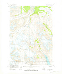
1958 Map of Tyonek C-6
USGS Topo · Published 1974About this map
Triumvirate Glacier and Trimble Glacier dominate this interior Alaskan landscape, their massive icy flows joined by a complex network of crevasses and glacial meltwater. The drainage pattern is defined by the Trimble River, which is fed by the converging waters of the North Branch and South Branch. This mid-century survey captures the region during a period of extensive aerial photogrammetric mapping by the U.S. Geological Survey, documenting the high-altitude terrain before significant modern shifts in glacial margins.
Find a feature on this map
9 named features on this map. Tap any name to fly to it.
Don’t see what you’re looking for? This feature index may not catch every label — zoom into the map to look around manually.
Map Details
Editions of this 1958 Tyonek C-6 Map
2 editions found
Other maps of this area

1949 · Tyonek
USGS Topo · 1:250,000

1951 · Tyonek
USGS Topo · 1:250,000

1954 · Tyonek C-5
USGS Topo · 1:63,360

1954 · Tyonek D-5
USGS Topo · 1:63,360

1958 · Tyonek C-6
USGS Topo · 1:63,360

1958 · Tyonek B-5
USGS Topo · 1:63,360

1958 · Tyonek B-6
USGS Topo · 1:63,360

1958 · Tyonek D-6
USGS Topo · 1:63,360

1958 · Tyonek
USGS Topo · 1:250,000
1958 · Tyonek B-7
USGS Topo · 1:63,360