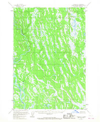
1954 Map of Tyonek D-2
USGS Topo · Published 1967About this map
The Kahiltna River and Yentna River dominate this mid-century landscape in the Matanuska-Susitna region, where complex glacial drainage patterns are evident across a vast expanse of wetlands. Surveyed in the early 1950s, the terrain is defined by its water-rich geography, including the lengthy course of Kroto Creek and smaller basins like Neil Lake and Lockwood Lake. Human presence is exceptionally sparse, marked only by isolated Cabins and surveying landmarks such as VABM 138 Moose. The intricate network of swamps and streams between Moose Creek and the larger river systems illustrates the unorganized and roadless nature of the Alaskan interior at this time, offering a clear view of the natural hydrology before any modern development or infrastructure altered the drainage basins.
Find a feature on this map
9 named features on this map. Tap any name to fly to it.
Don’t see what you’re looking for? This feature index may not catch every label — zoom into the map to look around manually.
Map Details
Editions of this 1954 Tyonek D-2 Map
4 editions found
Other maps of this area

1949 · Tyonek
USGS Topo · 1:250,000

1950 · Talkeetna
USGS Topo · 1:250,000

1951 · Talkeetna
USGS Topo · 1:250,000

1951 · Tyonek
USGS Topo · 1:250,000

1952 · Tyonek D-1
USGS Topo · 1:63,360

1952 · Talkeetna A-1
USGS Topo · 1:63,360

1952 · Tyonek C-1
USGS Topo · 1:63,360

1954 · Tyonek D-2
USGS Topo · 1:63,360

1954 · Tyonek D-3
USGS Topo · 1:63,360

1954 · Tyonek D-1
USGS Topo · 1:63,360