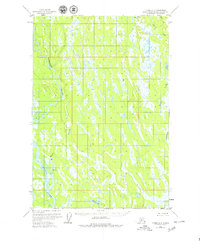
1954 Map of Tyonek D-2
USGS Topo · Published 1979About this map
The Kahiltna River and the Yentna River dominate this subarctic landscape in the mid-1950s, as they converge amidst a complex network of wetlands and minor tributaries. This environment is defined by an intricate system of small water bodies, including Lockwood Lake and Neil Lake, which are separated by low-lying terrain and dense vegetation. Human presence is extremely sparse, marked only by isolated structures like a Cabin along the banks of the Moose Creek and near the southern lakes.
Find a feature on this map
9 named features on this map. Tap any name to fly to it.
Don’t see what you’re looking for? This feature index may not catch every label — zoom into the map to look around manually.
Map Details
Editions of this 1954 Tyonek D-2 Map
4 editions found
Other maps of this area

1949 · Tyonek
USGS Topo · 1:250,000

1950 · Talkeetna
USGS Topo · 1:250,000

1951 · Talkeetna
USGS Topo · 1:250,000

1951 · Tyonek
USGS Topo · 1:250,000

1952 · Tyonek D-1
USGS Topo · 1:63,360

1952 · Talkeetna A-1
USGS Topo · 1:63,360

1952 · Tyonek C-1
USGS Topo · 1:63,360

1954 · Tyonek D-2
USGS Topo · 1:63,360

1954 · Tyonek D-3
USGS Topo · 1:63,360

1954 · Tyonek D-1
USGS Topo · 1:63,360