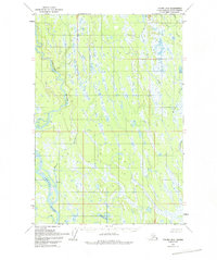
1954 Map of Tyonek D-2
USGS Topo · Published 1993About this map
The Kahiltna River and Yentna River dominate this 1954 topographic study, winding through a complex network of wetlands and minor tributaries in the Matanuska-Susitna region. Based on aerial photography from 1952, the map documents a largely roadless wilderness defined by water and low-relief terrain. Braided channels and numerous unnamed ponds characterize the landscape, where human presence is sparse, marked only by isolated Cabin locations. Along the eastern edge, the drainage systems of Kroto Creek and Chijuk Creek feed into a mosaic of small lakes including Neil Lake and Lockwood Lake. The absence of roads or established trails at the time of the 1954 field annotation reflects the region's character as an inaccessible river-and-wetland corridor, where seasonal water levels and shifting silt deposits dictated the location of temporary settlements and travel routes.
Find a feature on this map
11 named features on this map. Tap any name to fly to it.
Don’t see what you’re looking for? This feature index may not catch every label — zoom into the map to look around manually.
Map Details
Editions of this 1954 Tyonek D-2 Map
4 editions found
Other maps of this area

1949 · Tyonek
USGS Topo · 1:250,000

1950 · Talkeetna
USGS Topo · 1:250,000

1951 · Talkeetna
USGS Topo · 1:250,000

1951 · Tyonek
USGS Topo · 1:250,000

1952 · Tyonek D-1
USGS Topo · 1:63,360

1952 · Talkeetna A-1
USGS Topo · 1:63,360

1952 · Tyonek C-1
USGS Topo · 1:63,360

1954 · Tyonek D-2
USGS Topo · 1:63,360

1954 · Tyonek D-3
USGS Topo · 1:63,360

1954 · Tyonek D-1
USGS Topo · 1:63,360