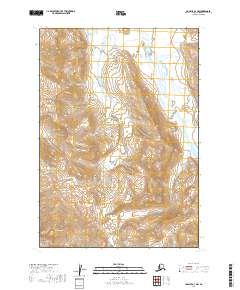
2019 Map of Ugashik A-3 NW
USGS Topo · Published 2019About this map
Mt Chiginagak dominates the southwestern corner of this landscape in the Lake and Peninsula Borough. The terrain is defined by the significant drainage systems of the Dog Salmon River to the northeast and Wandering Cr, which meanders through the central portion of the survey. The mapping reveals a remote environment where glacial or volcanic activity has shaped the sharp contour gradients, particularly surrounding Volcano Cr. The area is part of a larger network of hydrological features that feed into the region's broader watershed, illustrating the complex natural water systems of the Alaska Peninsula before any significant human development or infrastructure was established in this specific quadrangle.
Find a feature on this map
8 named features on this map. Tap any name to fly to it.
Don’t see what you’re looking for? This feature index may not catch every label — zoom into the map to look around manually.
Map Details
Editions of this 2019 Ugashik A-3 NW Map
This is the sole edition of this map. No revisions or reprints were ever made.
Other maps of this area

1943 · Ugashik
USGS Topo · 1:250,000

1948 · Ugashik
USGS Topo · 1:250,000

1949 · Ugashik
USGS Topo · 1:250,000

1951 · Ugashik B-3
USGS Topo · 1:63,360

1954 · Ugashik A-3
USGS Topo · 1:63,360

1954 · Ugashik B-4
USGS Topo · 1:63,360

1963 · Ugashik A-4
USGS Topo · 1:63,360

1963 · Ugashik
USGS Topo · 1:250,000
2019 · Ugashik A-3 SE
USGS Topo · 1:25,000
2019 · Ugashik B-4 SE
USGS Topo · 1:25,000