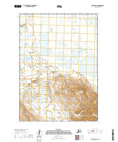
2019 Map of Ugashik B-4 SW
USGS Topo · Published 2019About this map
Dog Salmon River meanders across the northeastern corner of this remote Alaskan terrain, where the lowlands are defined by an intricate network of unnamed lakes and wetlands. The southern reaches of the quadrangle rise sharply into unnamed peaks and ridgelines, with contour lines illustrating the transition from the marshy coastal plain to the elevated interior. This map focuses on the raw topography of the Lake and Peninsula Borough, captured during a 2019 survey that emphasizes the natural drainage patterns and the varied relief of the land. Because no human settlements, roads, or structures are recorded on the sheet, the map serves as a primary record of the hydrological systems and the natural state of the peninsula's interior before significant human development or infrastructure was established.
Find a feature on this map
7 named features on this map. Tap any name to fly to it.
Don’t see what you’re looking for? This feature index may not catch every label — zoom into the map to look around manually.
Map Details
Editions of this 2019 Ugashik B-4 SW Map
This is the sole edition of this map. No revisions or reprints were ever made.
Other maps of this area

1943 · Ugashik
USGS Topo · 1:250,000

1948 · Ugashik
USGS Topo · 1:250,000

1949 · Ugashik
USGS Topo · 1:250,000

1954 · Ugashik B-4
USGS Topo · 1:63,360

1954 · Ugashik B-5
USGS Topo · 1:63,360

1963 · Ugashik A-4
USGS Topo · 1:63,360
1963 · Ugashik A-5
USGS Topo · 1:63,360

1963 · Ugashik
USGS Topo · 1:250,000
2019 · Ugashik B-4 SE
USGS Topo · 1:25,000
2019 · Ugashik A-5 NE
USGS Topo · 1:25,000