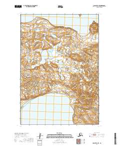
2019 Map of Ugashik D-2 SW
USGS Topo · Published 2019About this map
Becharof Lake and Upper Ugashik Lake dominate the northern and southern fringes of this remote Alaskan peninsula landscape. The interior terrain is defined by the unique volcanic landforms of the Ukinrek Maars, a pair of phreatomagmatic craters formed during a rare 1977 eruption on the shores of Becharof Lake. Nearby, the prominence of The Gas Rocks punctuates the shoreline, marking a site of significant geological and geothermal interest in the Lake and Peninsula Borough. The map reveals a wild, roadless expanse where the hydrological connection between these two massive lake systems is primary, illustrating the undeveloped character of the Alaska Peninsula. For researchers and geologists, this record provides a clear view of the land's surface as it appeared in the early 21st century, centered on these distinct volcanic and aquatic landmarks.
Find a feature on this map
8 named features on this map. Tap any name to fly to it.
Don’t see what you’re looking for? This feature index may not catch every label — zoom into the map to look around manually.
Map Details
Editions of this 2019 Ugashik D-2 SW Map
This is the sole edition of this map. No revisions or reprints were ever made.
Other maps of this area

1943 · Ugashik
USGS Topo · 1:250,000

1948 · Ugashik
USGS Topo · 1:250,000

1949 · Ugashik
USGS Topo · 1:250,000

1951 · Ugashik C-2
USGS Topo · 1:63,360

1951 · Ugashik D-3
USGS Topo · 1:63,360

1951 · Ugashik C-3
USGS Topo · 1:63,360

1951 · Ugashik D-2
USGS Topo · 1:63,360

1963 · Ugashik
USGS Topo · 1:250,000
2019 · Ugashik D-3 NE
USGS Topo · 1:25,000
2019 · Ugashik D-3 SE
USGS Topo · 1:25,000